Friday, 11 April 2014

Churches


All of the churches highlighted hereunder contribute significantly to the historical architecture of Port-of-Spain. Most, including the Cathedral of the Immaculate Conception, Greyfrier’s Church and Holy Trinity Cathedral were built by the country’s first civilian governor, Sir Ralph Woodford (Trinidad and Tobago Tourism Development Company Limited). The location of most churches in downtown Port-of-Spain signified the importance of religion to Britain at the time. The location of these beautiful historic churches in the CBD adds not only to the city's style, but also its peaceful ambience and perhaps its moral. All of the churches are considered to be traditional architecture as the styles mimic structures from Britain since Trinidad was a British colony at the time.
The Holy Rosary Church construction started in 1892 and is gothic revival style. The stained glass lancet windows came from Toulouse, France.
The Holy Rosary Church
 
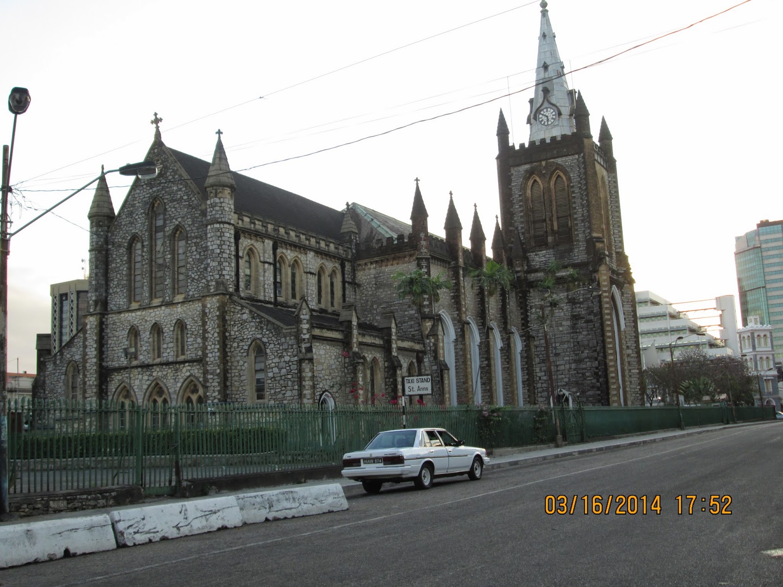
The All Saint Anglican Church was built in 1886 of stone from Laventille quarry. Although this church was built with local materials, the authentic English design classifies it as traditional architecture.
The All Saints Anglican Church
 
Greyfrier’s church was built in 1837 to accommodate the first set of Presbyterians in Trinidad under British rule.
Greyfrier's Church
 
The Holy Trinity Cathedral is Late Georgian style mixed with Gothic as well as elements of the Victorian age. It was the first Anglican Church in Trinidad, was swept by fire in 1808 and rebuilt in 1816.
The Holy Trinity Cathedral
 
Last but not least, the Cathedral of the Immaculate Conception located on the eastern end of the Brian Lara Promenade was completed in 1836 and is one of the oldest Catholic Cathedrals in Trinidad.
The Cathedral of the Immaculate Conception


Reference List


Port-of-Spain's Central Business District


Approaching Port-of-Spain's CBD


Approaching Port-of-Spain, a view of majestic structures await as this capital asserts its power with its towering multi-storey buildings. Immediately, one can see that the CBD entails an administrative and commercial center. The twin towers (first 2 buildings from the left) are part of the Eric Williams Financial Complex where the Central Bank and Ministry of Finance are housed. To the right is the recently completed Nicholas Tower, a commercial office building. The other structures are also government buildings and all of them are classified as modern architecture. According to Heynen (1999, p. 25) modernity involves the concerted struggle for progress, uniting workers, industrialists, and artists around a common goal. Here, the bourgeois modernity of capitalist civilization takes flight and politics, economics and culture fall under the same umbrella, which according to Le Corbusier, causes the collapse of an integrated experience of life. Modern architecture evolved from the industrial revolution where an abundance of steel, glass and other building materials were mass produced. It is perceived as a rejection of traditional architecture and a way of capturing the space of the present generation. The above photograph highlights the dominance of politics and economics in our capital and the culture of imitating the designs of the Global North in our high rise buildings. These high rise government and commercial buildings however are located mostly on Abercromby and Edward Streets (seen below), west of Fredrick Street, which is the division between retail and administrative parts of the CBD.


One of the high rise twin towers
 
High rise buildings on the Western end of the CBD


The photograph below captures Charlotte Street which is one of the main commercial and retail streets in the CBD. Architecturally, the buildings in this part of the CBD are 2–3 storeys high and are multi-functional. They are planned to accommodate the pedestrians by their walk-through design to connect one street to the other. Bradford City Mall in this photograph for example connects Charlotte Street to Henry Street, another commercial hub. In addition, the second photograph below shows Plaza Espermaria which has the same walk-through design. Shoe Avenue is also highlighted on Henry Street where many different varieties of shoes can be bought in this area bustling with commercial activity.


Charlotte Street


Shoe Avenue, Henry Street


The division of the CBD into a commercial and administrative part can be compared to that of New Orleans where Brooks and Young (1993) described that Poydras Street housed offices mainly of the petrochemical industry and Canal Street was the retail core. It is also worth mentioning that the Hyatt Regency Hotel (seen in the photograph below) is the main commercial building at the waterfront and it also forms part of the high rise buildings on the western end of the CBD. This waterfront design is classified as modern architecture and can also be compared to New Orleans’s riverfront which over time developed into a main tourist attraction.
 

The Hyatt Regency Hotel at the Waterfront


Reference List
 
 
  • Brooks, Jane S., and Alma H. Young.1993. "Revitalising the central business district in the face of decline: The case of New Orleans, 1973-1993." The Town and Planning Review 64 (3): 251-271


Housing in the Central Business District (CBD)


As one passes the Beetham Gardens traveling in a westerly direction into Port-of-Spain, the first residential area encountered is the low income housing area of Port-of-Spain’s CBD as seen below.
 
Working Class Apartment Buildings
This area houses the working class neighbourhood and is rarely seen by the public because many people do not venture into these areas. Hence these photographs were taken while the vehicle was still in motion because of the reputation of high crime and violence. This neighbourhood which reflects that of George and Nelson Street was specifically chosen to highlight because having walked through the CBD recently, I realized that I never took note of the type of housing associated with this hub of commercial activities. The location of this working class residential area is indicative of Ernest Burgess’s concentric zone model although Port-of-Spain does not have a factory zone. The CBD similarly, is the center and is surrounded by the working class residential.
One of the access routes between the Neighbourhood and the CBD
 
The buildings are visibly compact and it can be seen that some attempt at redevelopment has been made as seen by the newly applied paint on the buildings below. The architecture however is classified as vernacular since it is very simple and common materials are used to portray the culture of the people.
Refurbished Housing
According to Pacione (2009) the attitude of the government towards these settlements has varied considerably, ranging from hostility, to suppression, to toleration and occasional support. While these housing developments were initiatives by the government to supply housing to the working class areas, we see discontent by the residents in this video and article.
 
Reference List
  • Pacione, M. 2009. Urban Geography: A Global Perspective. London: Routledge.

Monday, 24 March 2014

Placecheck Findings of Port-of-Spain's CBD and Belmont, Trinidad


Placecheck Findings of Port-of-Spain’s Central Business District (CBD)

What do I like? What needs protecting? What would I like more of?

When one stands on the Brian Lara Promenade which runs from east to west along the CBD, one can appreciate the diverse culture and ethnicity of Trinidad and Tobago. People of all ages and walks of life can sit on the benches provided just to enjoy the inner city ambience and people passing quickly by.
The Brian Lara Promenade
                                        
Social interaction is also encouraged at the Brian Lara Promenade as seen by the checkers board painted unto the tables.
The checkers board painted on the table at the Promenade


As one walks through the heart of the city, a vibrant, flourishing retail and commercial hub invades your space. Charlotte Street, Henry Street and Fredrick Street are flooded with street vendors and stores which all provide a range of goods to supply the local market such as textile, shoes, jewelry, clothes, fruits and vegetables, grocery items, art and craft etc.
Charlotte Street, Port-of-Spain
 
Typical of a CBD, many multifunctional buildings are seen which not only house stores but also government, law and business offices. Most of the malls such as Bradford City, Uptown and Arlene’s to name a few promote pedestrian traffic by being walk-through in design. This compliments the design of the CBD which encourages pedestrian traffic. The green areas in the CBD such as Woodford Square visually enhance the appearance of the city and certainly needs protecting in the short, medium and long-term. When a passerby was asked what he appreciates most about the city, he responded, “I think Port-of-Spain is a beautiful city and I love sitting here and observing.” Maintenance workers were seen cleaning Woodford Square; however in the long-term perhaps a green policy can be implemented to further protect these areas.
Woodford Square
                                    

What don’t I like? What needs changing now? What is getting worse?
Two chronic issues in the CBD appear to be inadequate accommodation for homeless people and street vendors. Many homeless people are scattered about the Brian Lara Promenade and their trolleys are stored there as well. High stench of urine at trees and toilet paper is also seen which indicates that there isn’t facilities for them to use or to stay in the city.
Issues with homeless people on the Promenade
                              
Also, street vendors have invaded the streets causing further congestion for motor vehicles. Perhaps, a specific area(s) can be designated for these vendors. Another issue observed is that while the short blocks, grid-like system and walk-through malls encourage pedestrian traffic not enough is done to facilitate them. The pavements are high in some areas, manholes are damaged and uncovered and there are no pedestrian crossing areas at most intersections. Pavements need to be made and maintained in such a way where disabled and elderly people can commute comfortably. Pedestrian crossings must be placed at most intersections to promote safe and easy crossing at least in the short-term.
No pedestrian crossing facilities at busy corners


What needs to be improved?
In the short-term, parking facilities need to be improved both in appearance and number. There is insufficient parking for the number of cars entering the city and many people resort to double parking on the roads, creating more traffic. Perhaps multi-storey parking lots can be built in the short and medium-term. Some empty lots of land in the CBD are used as public car parks but most of them are very old and unkempt. A passer-by who commutes every day to and from Port-of-Spain was asked what he dislikes the most. He indicated that transport within the city is not efficient enough and he thinks that a shuttle service should be put in place. This can be a medium-long term solution. However, certainly I think that a future goal of this city should be to restrict motor vehicular traffic within the city and put in place more pedestrian friendly infrastructure, bicycle rentals and an efficient shuttle service.

Placecheck Findings of Port-of-Spain’s first Suburb, Belmont

What do I like? What needs protecting? What would I like more of?

Belmont or Freetown as the slaves called it is oozing with history and culture of freed slaves since 1834 and even before. According to Scantlebury (2014), slaves gathered in sheds of Belmont and played the instruments to ease their pain. These sheds are still part of the architecture of Belmont and exist as mas camps where Carnival bands, costumes, jab jab, robber mas and jouvert originate in this ‘Mas Capital’ of Trinidad.
Glendon Morris Copper Works & Mas Camp
 
The promotion of arts has therefore been priority as also indicated by the location of Trinidad Theatre Arts here.
Trinidad Theatre Workshop


In this suburb of Port-of-Spain, low income housing intermingles with high income housing side by side which indicates that people of different class and standard of living exist within the same space of Belmont. Government services such as maintenance (CEPEP) spills over from Port-of-Spain so the people of this area benefits from this. The old architecture showcasing the heritage of Belmont needs to be preserved and maintained for both short and long-term timeframes. A museum can also be erected showcasing artifacts to further highlight the culture and history of the area. These measures will benefit tourism in the future.

What don’t I like? What needs changing now? What is getting worse?

The high level of land pollution is an eye sore in Belmont. Perhaps youth projects can be developed to create awareness of the problem and to clean up the area of excessive garbage.
Issue of littering in Belmont
 
The roads of Belmont are very narrow and this makes driving a bit difficult in this area. The government should therefore widen the roads as a long term project or promote cycling and shuttle services in the area. There are also many dilapidated, abandoned houses which have been left by failed businesses and family conflicts for land. This is not visually appealing to this area.
One of many dilapidated buildings


What needs to be improved?
The area of Belmont needs open public spaces such as parks and savannahs to encourage integration among the youths. This was a concern of one resident since they have to share the Queen’s Park Savannah in Port-of-Spain with other surrounding areas. Security appears to be a serious issue as seen by the barbed wire, high walls of the Belmont Boys Secondary School.
Secondary School with high, barbed wire walls


Perhaps, this community can establish a neighbourhood watch and patrol to aid as a crime deterrent. Youth empowerment through projects and public spaces will also help the crime situation in future. Street signs need to be redone since most of them are either very old or turned the wrong way. Pedestrian crossing has to be made a priority since no provisions of this nature were observed.

Assessing the CBD of Port-of-Spain and Belmont according to Jane Jacobs’ principles of Good Neighbourhoods

Both areas prove to be good neighbourhoods when Jane Jacobs’ principles are applied. The CBD fulfills all the criteria of being multi-functional (commercial, retail, recreational, residential), mixed blocks with different buildings of different ages and conditions (old churches and buildings alongside modern, majestic structures), having streets with short blocks and numerous streets and having a dense concentration of people of various ages occupying the space for different purposes. Belmont fulfills these criteria also, but it is characterized as more of a residential area with commercial activity in the form of small businesses scattered between houses. There is a dense concentration of people living in the area as seen by the nucleated settlement pattern, however not much pedestrian traffic is observed. Therefore, Jane Jacobs’ principles define both areas as good neighbourhoods in different ways. While her principles prove to be mostly successful in highlighting good neighbourhoods, they do not take into account security and pollution which seem to be major issues in Belmont in particular.

What makes a successful CBD?
In my opinion, Port-of-Spain is a successfully functioning CBD where it is a commercial and retail hub and also provides a recreational environment for commuters as seen at the Brian Lara Promenade and Woodford Square, among others. Government buildings such as the twin towers and parliament are also prominent which shows that the government has a strong base and provides numerous services in the capital. Its design promotes pedestrian traffic and walking from one street to the other can be done with ease by the numerous connected streets and blocks and walk-through malls. However, the needs of the public such as proper vending areas, pavements catering for elderly and disabled people and facilities for homeless people need to be addressed to make Port-of-Spain an even more efficient CBD.


Monday, 10 February 2014


Urban Slum: A part of urban architecture and design?
The Beetham Gardens, Port-of-Spain Trinidad
The Beetham Gardens, captured in the above photograph is the first scene that invites one into the capital city of Port-of-Spain, Trinidad from an easterly direction. This photograph was taken in motion since this is known to be a very violent area, however, I felt that it was important to highlight because this is a depressed area of the city. This scene reflects dilapidated houses with collapsed roofs, unpainted walls and an extremely degraded, polluted environment. This is referred to as an urban slum. UN-Habitat defines a slum in many different ways but most simply as a heavily populated urban area characterized by sub-standard housing and squalor. It is the most visible indicator of urban poverty in developing countries and generally lacks clean water, electricity, sanitation and other basic amenities.
Is this heavily populated area of sub-standard housing and squalor a part of the urban design and architecture of Port-of-Spain? Majestic structures in this capital such as government buildings, churches, schools, hotels and businesses are built with specific forms that fit into the design of the city to make it functional, attractive and sustainable. Some of these structures are categorized as traditional architecture which refers to architecture as an art and is associated with the design of great buildings. Others fit into vernacular architecture which refers to everyday buildings not designed by professionals (Hall and Barrett 2012, 190). Urban architecture in general, is said to give space a cultural expression (Glassie 2000).
The Beetham Gardens is a space that reflects a culture of poverty, crime, overcrowding, unemployment and poor structural quality. Mumford (1938) believed that in western civilizations, slums were formed due to rapid mechanization in urban areas, which caused an influx of people from rural areas. He believed that because the city did not plan to accommodate such masses, they spilled over into degraded areas and slums. In Trinidad, this urban slum may have been formed due to rapid industrialisation, the decline in the number of persons working in agriculture, an influx of illegal immigrants and insecure land tenure to name a few.
However, regardless of the causes of the urban slum formation in Port-of-Spain, its design certainly cannot be classified as that of stylish, modern or even that of great buildings. Rather, it falls into the category of vernacular architecture because its design is determined by local conditions, and style plays no role in its look. It is built by the people who settle there to provide shelter and satisfy very basic needs since many of them are ‘squatting’ or have no ownership of the land on which they dwell. Slums may be considered the eye sore of a city and certainly are not a part of any urban design but they do contribute to a city’s indigenous (vernacular) architecture and by extension its cultural expression.
 
Reference List
  • Glassie, Henry. 2000. Vernacular Architecture. Indiana: Material Culture.
  • Hall, Tim, and Heather Barrett. 2012. Urban Geography. New York: Routledge.
  • Mumford, Lewis. 1938. The Culture of Cities. New York: Harcourt, Brace and Company.